{title}
{publish}
{head}
Key transport routes running East–West, connecting coastal and mountainous areas, are gradually taking shape as dynamic economic corridors. These routes provide a solid foundation for fully unlocking the potential and strengths of the East–West Economic Corridor, helping Quang Tri accelerate its socio-economic development.
Facilitating trade
Director of the Department of Construction, Tran Huu Hung, affirmed that the East-West transport corridors have been playing a significant role in boosting bilateral international trade, strengthening Quang Tri’s competitiveness in the global economic integration process. Additionally, these corridors are unlocking regional economic potentials, driving economic restructuring, and fostering urban development.
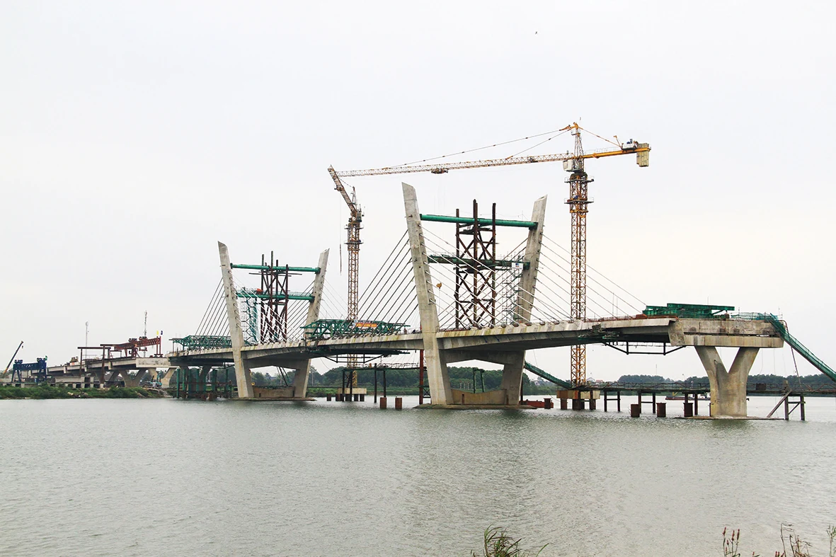
The Thach Han 1 Bridge, crossing the Thach Han River and connecting Dong Ha City with Trieu Phong District, is under construction as part of the Coastal Road project connecting the East-West Economic Corridor. This project is creating numerous opportunities for regional connectivity and urban development. Photo: L.M
In 2024, the import-export turnover through the two international border gates, Lao Bao and La Lay, reached nearly US$1 billion. Of this, the import-export turnover at Lao Bao International Border Gate was $645.77 million, an increase of 45.87%, with a total cargo weight of 1.18 million tons.
At La Lay International Border Gate, the import-export turnover was $250 million, with a total cargo volume of 2.26 million tons; the total value of transit goods was $8.93 billion. This highlights the vital role of these two major transport routes in enhancing Quang Tri’s international trade and the regional connectivity provided by National Highway 9 and National Highway 15D.
Recognizing the importance of these two routes, Quang Tri province has initiated investments to upgrade and expand them. For National Highway 9, given its strategic position, the province has collaborated with the Ministry of Construction to review and finalize the proposal for the construction of the Cam Lo-Lao Bao expressway under the public-private partnership (PPP) model. The project is set to have four lanes, with a design speed of 100 km/h, a roadbed width of 24.75 meters, and a total length of 56 km. The estimated investment for the project is approximately $593 million, with Son Hai Group being the project investor.
National Highway 15D will create a connection with National Highway 15B in Laos, as well as the Thai and Myanmar road networks, forming the La Lay-My Thuy Corridor, which runs parallel to the East-West Economic Corridor. This corridor is strategically important, linking the North Central region with neighboring countries.
This route connects national transport axes such as National Highway 1 and the North-South Railway; specifically, it will connect National Highway 1 and the Cam Lo-La Son expressway and fully utilize the My Thuy Port, making it convenient for attracting investment and developing Quang Tri Industrial Zone and the Southeast Quang Tri Economic Zone.
National Highway 15D will feature between two and four lanes, with a total length of 84 km, divided into several investment phases. The segment from the Cam Lo-La Son expressway to National Highway 1 will be 34 km long and implemented via PPP, with an estimated investment of approximately $238 million. The segment from the western branch of the Ho Chi Minh Road to La Lay International Border Gate will be 12.2 km long, with an estimated investment of about $61 million.
In addition to the existing Cua Viet port, the My Thuy Port project, which was launched in early 2024 by the My Thuy International Port Joint Venture Company (MTIP), serves as an important transportation hub, providing access to the East Sea from Quang Tri on the East-West Economic Corridor. This port connects conveniently with many major transport routes, supporting the transportation of goods through economic corridors passing through Quang Tri. These transport routes, connecting East-West axes, also foster regional integration between mountainous and coastal areas, boosting development, economic restructuring, and urban growth.
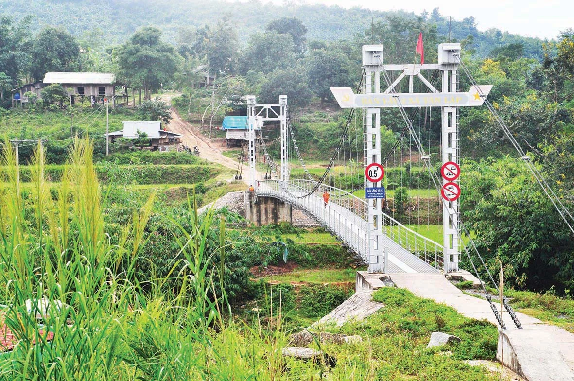
Lang Vay Bridge in Huong Hoa District. Photo: Tra Thiet
Supporting socio-economic development
One of the major projects aimed at creating change in connectivity and regional development is the Coastal Road Project, connecting the East-West Economic Corridor. This road stretches 55 km, with the first phase investment of over $85 million, passing through Vinh Linh, Gio Linh, Trieu Phong, and Dong Ha City. The project is currently under construction and is expected to be completed and operational soon.
Additionally, the project to connect the eastern and western branches of the Ho Chi Minh Road, spanning 21.4 km with an investment of about $9.7 million, aims to enhance connectivity between the two branches of the Ho Chi Minh Road. It will support the development of the northern Huong Hoa and western Vinh Linh regions while also providing a key route for disaster prevention and ensuring national security. The project has completed the construction of 11 km of the 15 km section, with the remaining 4 km currently undergoing natural forest clearance and expected to be completed and operational by 2025.
In parallel with these major breakthrough projects, many existing infrastructure projects are already effectively contributing to regional connectivity and development, such as National Highway 49C (41.1 km) from Cua Viet port to the Huế region; National Highway 9D (45.9 km) from Cua Viet port to Ben Quan town, Vinh Linh; National Highway 9F (25 km) from Truong Son Martyrs’ Cemetery to the junction with National Highway 9 at Trung Giang, Gio Linh; the Quang Tri coastal road system from the Quang Binh border to the Huế city border; and a road connection from National Highway 1 to the airport and coastal road (currently under construction).
The provincial road system includes DT.571, which connects National Highway 9D to the sea; DT.574 (7.53 km) from Cua Tung Beach to National Highway 1; DT.575A (10 km) from Gio Linh Town to National Highway 9 and Cua Viet Beach; DT.583 (5 km) connecting the sea with National Highway 49C; DT.582 (15 km) linking the sea with Hai Lang Town; and DT.582B (13.76 km), which connects the sea with Hai Truong Commune (aligned with the planned route for National Highway 15D from La Lay to My Thuy Beach).
With the existing, ongoing, and planned road networks, Quang Tri is establishing a robust transport infrastructure that connects with important national transport axes such as National Highway 1, expressways, the North-South Railway, and Quang Tri Airport. This comprehensive transport network links the coastal regions with urban areas, economic corridors, and dynamic economic zones, unlocking the full potential of border and marine economies. It enhances Quang Tri’s competitiveness in attracting investment, developing urban infrastructure, and ensuring sustainable growth for the province in the future.
Le Minh - Ngoc Mai

QTO - In Quang Tri, clean agricultural stores may not flaunt flashy signs or wide storefronts, but they are quietly becoming trusted places where consumers...
QTO - In a quiet village in central Vietnam, Le Minh Duc, 26, has turned his passion for ornamental fish into a promising startup, the first Koi breeding...